
Carrizo Plain National Monument
Soda Lake Rd
New Cuyama, CA
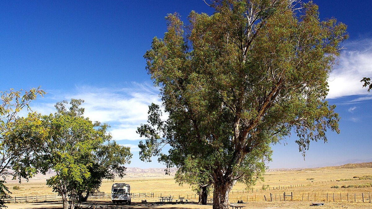
The last wide-open piece of old California, where the San Andreas Fault splits the earth and a good spring can turn the whole plain to color.
Three hundred years ago, much of California's interior was open grassland where pronghorn and tule elk grazed under enormous skies and spring rains turned the ground to wildflowers. Farms, cities, and highways swallowed nearly all of it. The Carrizo Plain is the great exception, a broad basin of native grassland that was never plowed under, and today it is protected as a national monument, the largest single piece of that vanished California still intact.
It is a place of big, plain drama. A shallow alkali lake called Soda Lake sits white and glittering at its center, the San Andreas Fault runs the length of the eastern hills in a line you can actually walk beside, and in the right wet year the whole plain erupts into a superbloom so bright it can be photographed from space. In between those big events it is simply quiet, empty, and beautiful, the sort of country you have to drive a long way to still find.
What Travelers Love
- The famous wildflower superblooms that can paint whole hillsides gold, purple, and orange in a good wet year
- Walking a marked trail right along the San Andreas Fault and seeing how it has bent a creek sideways
- Painted Rock, a huge horseshoe of sandstone the Chumash and Yokuts covered with ancient rock paintings
- The sheer emptiness and dark night skies, with pronghorn and elk out on the plain
Worth Knowing
- There are no services anywhere on the monument, so fill up on gas, water, and food before you drive in
- Cell phone service does not work out here, so download maps and tell someone your plans first
- Soda Lake Road is fine for a normal car, but the side roads turn to slick mud after rain and are best avoided when wet
- A superbloom depends on winter rain and is not guaranteed, so check the visitor center's updates before making a long trip just for flowers
Learn about Carrizo Plain National Monument
A remnant of the old California
Before Europeans arrived, the Chumash and Yokuts peoples lived on and around this plain for many thousands of years, hunting and gathering in a landscape rich with game and seasonal plants. Their most striking mark on the land is Painted Rock, a giant horseshoe-shaped alcove of sandstone rising out of the flat grass, its inner walls once covered with elaborate multicolored paintings. It remains one of the most important rock-art sites in the American West and a sacred place to Native people today.
The plain was later ranched but, unlike the Central Valley to the north, it was never converted to farmland, so its native grasses and animals survived. In January 2001 it was designated Carrizo Plain National Monument, jointly cared for by the Bureau of Land Management, the state, and the Nature Conservancy, in order to protect both its wildlife and its cultural sites. Pronghorn antelope and tule elk still range across the grassland, along with kit foxes, kangaroo rats, and the giant kangaroo rat, several of them found almost nowhere else.
Walking the San Andreas Fault
The Carrizo Plain is one of the best places on earth to see the San Andreas Fault with your own eyes. The fault, where two great slabs of the earth's crust grind past each other, runs clearly along the base of the eastern Temblor Range, and a short self-guided trail at Wallace Creek lets you stand right on it. There you can see how the fault has slowly dragged the two banks of a small creek out of line, so the streambed makes a strange sideways jog where none should be.
In the great earthquake of January 1857, one of the largest ever recorded in California, the ground here lurched about thirty feet in a single stroke. Geologists come from around the world to study this stretch of open, unbuilt ground because the fault's every movement is written so plainly across the land. For a visitor it turns an abstract idea from school into something you can walk up to and touch.
Soda Lake and the superbloom
At the heart of the plain lies Soda Lake, a shallow seasonal lake with no outlet, so the water that collects there each winter simply evaporates and leaves behind a broad crust of white alkali salts that shine like snow in the sun. A boardwalk carries visitors out over the lakebed to an overlook, and in wet months the lake draws sandhill cranes and other migrating birds to its edges.
The event that has made Carrizo Plain famous is the superbloom. When winter storms drop enough rain at the right times, the dormant seeds in the grassland burst open all at once, and by March and April the valley floor and the surrounding hills run in ribbons of goldfields yellow, purple phacelia, and orange fiddleneck. It does not happen every year, and it cannot be scheduled, which is part of what makes catching one feel like a genuine stroke of luck rather than a scheduled attraction.
Visiting Carrizo Plain
The monument is reached by Soda Lake Road, which runs the length of the plain and connects to State Route 58 to the north and to Route 166 near New Cuyama to the south. The main road is well kept and fine for an ordinary car, but the many dirt side roads can turn to impassable mud after rain, so save those for dry weather and stay on Soda Lake Road when it is wet. The Goodwin Visitor Center, open in the cooler months, is the place to get current conditions and directions.
Come prepared for genuine backcountry. There is no gas, no food, no water, and no cell signal anywhere on the monument, so you must bring everything you need and let someone know your plans before you go. Give the day room to breathe: walk the fault at Wallace Creek, take the boardwalk over Soda Lake, and if the timing is right for a bloom, simply drive slowly and let the color come to you. Stay for the night sky if you can, because with no towns for miles the stars over the plain are extraordinary.
Closest Boutels
The closest Boutel™ stays, so you can turn this stop into an overnight. Each is a place we chose through independent editorial review, never a paid placement.
Details
New Cuyama, CA
Frequently asked questions
What is Carrizo Plain National Monument?
Carrizo Plain National Monument is a vast, remote grassland in California's interior, southeast of San Luis Obispo, often described as California's own Serengeti for its wide-open landscape and wildlife. This starkly beautiful plain is famous for its spectacular spring wildflower superblooms in wet years, the shimmering Soda Lake, abundant wildlife including pronghorn and sandhill cranes, ancient Native American rock art at Painted Rock, and a dramatic stretch of the San Andreas Fault visible across the land. Wild, uncrowded, and expansive, Carrizo Plain offers solitude, natural wonder, and geological and cultural fascination far off the beaten path.
When can you see the wildflower superbloom at Carrizo Plain?
Carrizo Plain is famous for spectacular wildflower superblooms in spring, typically in years with good winter rainfall, when the hills and plain can erupt in vast carpets of color, drawing photographers and nature lovers from far away. The exact timing varies by year and rainfall, usually peaking sometime in spring, and in dry years the blooms may be modest or absent. Because it depends on the weather, checking recent bloom reports before you go is wise. When conditions align, the superbloom is an unforgettable natural spectacle.
What should I know before visiting Carrizo Plain National Monument?
Carrizo Plain is extremely remote with very few services, no reliable water or fuel, unpaved roads that can be impassable when wet, and limited cell coverage, so come fully prepared with plenty of water, food, fuel, and supplies, and check road conditions before you go, especially after rain. The heat can be intense in summer. Bring a map, tell someone your plans, and be self-sufficient. During superblooms it can get crowded on the narrow roads. Thorough preparation and self-reliance are essential for safely enjoying this wild, isolated monument.
When is the best time to visit Carrizo Plain National Monument?
Spring is the prime time, especially for the famous wildflower superblooms in wet years and for pleasant temperatures, along with wildlife viewing, while winter can be good for seeing sandhill cranes and pronghorn but roads may be muddy, and summer brings intense heat with little shade, making it less comfortable. Fall is quiet and mild. For the wildflowers and best overall conditions, spring is ideal, though timing depends on rainfall. Checking bloom and road conditions before you go helps you plan the best possible visit.
What is near Carrizo Plain National Monument?
Carrizo Plain is in a remote interior region southeast of San Luis Obispo and west of Bakersfield, far from major towns, with the small community of California Valley nearby and the coastal areas of San Luis Obispo County a drive to the west. Because it is so isolated, it is largely its own destination. That makes Carrizo Plain National Monument a remote natural wonder best planned as a dedicated trip, combined perhaps with the broader Central Coast, for those seeking wildflowers, wildlife, and wide-open solitude.
Nearby

Los Padres National Forest
32 miles away
Nearly two million acres of wild coast ranges wrap the Cuyama Valley in far northern Santa Barbara County, one of the last strongholds of the California condor and home to ancient Chumash rock art in...
Cold Spring Tavern
45 miles away
Cold Spring Tavern began as a stagecoach relay station on the old coast road through the Santa Ynez Mountains north of Santa Barbara, positioned at the base of the San Marcos Pass climb where horses w...

Old Mission Santa Ines
46 miles away
The nineteenth Spanish mission, founded in 1804 and still an active parish, sitting on a rise above the Santa Ynez Valley at the east edge of Solvang.